Limited time only! Book now for 25%* down and pay the second installment of 25% 30 days later.
Limited time only! Book now for 25%* down and pay the second installment of 25% 30 days later.
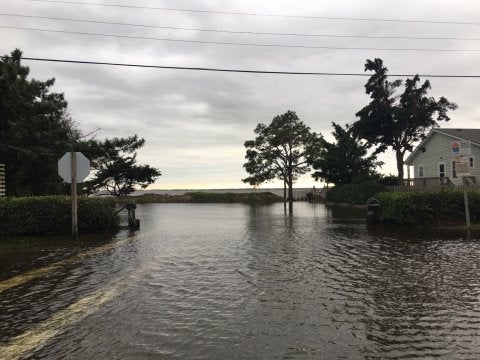
That was one heck of a Saturday night… I think saying the forecasters were wrong about Hurricane Matthew’s intensity and track would be an understatement. Around 10pm on Saturday night, the Outer Banks was formally greeted by the outer bands of Hurricane Matthew and we were pounded all night long (and into Sunday afternoon) with torrential rain and winds about double of what was forecasted (sustained 50-60+mph, gusts near 90mph clocked). Timbers were swaying and homes were flooding. Almost all of the beach road from Kill Devil Hills into Nags Head is submerged… anywhere from about 6″ of water to several feet in places. Low lying neighborhoods throughout the Outer Banks took on many inches of water and with the ground already saturated there is almost nowhere for it to go.
A large portion of our regular, administrative staff have been all over the beach today assessing homes for damage, and making those that are actually accessible safe and presentable for any of your check-ins. At the time this was published, Dare County is still not allowing those with an out of town driver’s license over the bridges (unless you have Priority 1 or Priority 2 permits). The portion of staff that isn’t out assessing damages are actively taking your phone calls to try and keep confusion at a minimum and everyone informed and assisted. I will post a few local photos and videos below this post. Rest assured, the Outer Banks isn’t destroyed, just having some down time. We who call this place home are accustomed to this type of weather, but it doesn’t mean we like it or can recover any faster. Stay in touch with us on our social media channels (follow the links at bottom of this page) and only call if you absolutely must. Dare County will probably have another update this afternoon so stay tuned for more updates.
-Robert Kissell
We’ve gone through a few more updates from both the National Weather Service and Dare County Emergency Management.. and the consensus is that the Outer Banks will experience tropical storm force winds at worst, and heavy rain is anticipated. With most of the beach towns already saturated, this may make for flash flooding and travel restrictions throughout. If you’re on the way to the Outer Banks, seriously consider waiting it out until this system rolls out away from us in the latter half of Sunday. There are no guarantees about the storm severity and road closures could impact travel at any time. We’ll keep the updates pumping to our Facebook page and a video out shortly. Stay safe and be wise when it comes to any travel you do this weekend!
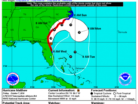
Hurricane Matthew is making its move onto the coast of Florida as we speak… so make sure to keep all those in the path in your thoughts this evening. The 5PM EST update from the NHC has arrived, and looks to be just about identical in terms of track and intensity. I believe tomorrow morning’s 5AM update may prove the most conclusive for how things will play out for the impact on the Outer Banks… stay tuned!
The 2PM EST update from the National Hurricane Center did not bring much more information other than a position update… the next forecast update should be here shortly before 5PM EST. However, Dare County Emergency Management has released updated information stating the county has no current plans for an evacuation if the storm holds its track and is only anticipating high winds and localized flooding.
The 11am forecast has been released, and things are now looking like a loop may be in the cards. I have yet to see a long term animated loop but this is going to be very interesting to say the least!
Just waking up and checking the 5am update, looks like even more south eastern tracking for the hurricane may be in store after a landfall in FL/SC. There’s still a lot of uncertainties but we’ll update again after the 11am NWS bulletin.
The 5:00pm EST update by the National Weather Service has arrived early… and looking even more promising. The forecast track looks further offshore towards the end of the week but we have to wait and see how it plays out, and compares to the ECMWF models that have historically been very accurate.
Well, this is our first blog post regarding Hurricane Matthew, but we’ll add updated entries as the storm makes its way near our coast. The past few days have been a little nerve wracking to say the least, but we’re getting a clearer picture of what may be in store for the Outer Banks this weekend. Below is a video taken in Nags Head around 1pm this afternoon, and we’ll keep more coming as we go along.
The beach is already wild. Winds are steady over 20mph out of the northeast and dangerous rip currents are all over. While this is not from the hurricane, it’s only going to increase as the week moves along. Right now the forecasted track of the storm includes a promising turn to the east, but at 5pm tonight we may have a newer path from the National Weather Service. Follow our Facebook page and the National Hurricane Center webpage for the latest information.
for the latest news, local events, and much more!
© 2024 Village Realty LLC | Sitemap | Website Terms of Use | Privacy Policy | Lost and Found